让isis支持高德地图
概述
由于项目需要用到地图,虽然isis的插件库里有个现成的地图实现,不过用的google地图,虽然google地图可以不用注册Appkey,但完全打不开。所以打算改成国产地图。
效果
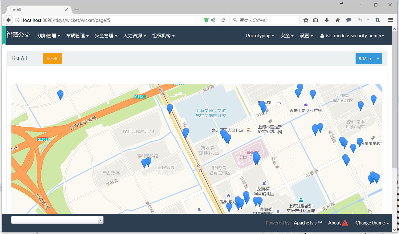
先看下运行效果。
列表中的效果:
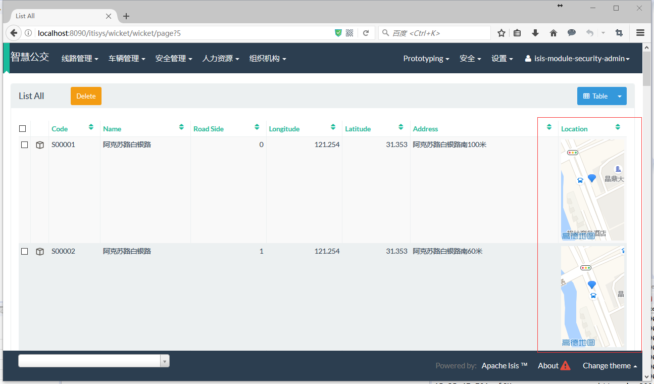
整体效果:
详细效果:

实现思路
高德地图的API跟Google地图类似,编程模型也相同,甚至很多类的命名都一样的。所以,从Google迁到高德还是比较容易的。
高德跟Google一样,用一个DIV来渲染地图。根据Vicket的编程方式,这个Div使用一个组件来表示,这个组件包含了相应的属性和呈现出来的模板及脚本。
先看下Google的模板,很简单在Panel里放了一个Div:
<html xmlns:wicket>

    <body>

    <wicket:panel>

        <div wicket:id="map" style="width:100%; height:100%"></div>

    </wicket:panel>

</body>

</html>
Google的客户端对应的初始化脚本:
/*

 * Licensed to the Apache Software Foundation (ASF) under one or more

 * contributor license agreements.  See the NOTICE file distributed with

 * this work for additional information regarding copyright ownership.

 * The ASF licenses this file to You under the Apache License, Version 2.0

 * (the "License"); you may not use this file except in compliance with

 * the License.  You may obtain a copy of the License at

 *

 *      http://www.apache.org/licenses/LICENSE-2.0

 *

 * Unless required by applicable law or agreed to in writing, software

 * distributed under the License is distributed on an "AS IS" BASIS,

 * WITHOUT WARRANTIES OR CONDITIONS OF ANY KIND, either express or implied.

 * See the License for the specific language governing permissions and

 * limitations under the License.

 */

/*

 * Wicket GMap3

 *

 * @author Tilman M�ller

 * @author Joachim F. Rohde

 */

// Wicket Namespace

if (typeof(Wicket) === 'undefined') {

    window.Wicket = {};

}

else if (typeof(Wicket) !== "object") {

    throw new Error("Wicket already exists but is not an object");

}

function WicketClientGeocoder() {

    try {

        this.coder = new google.maps.Geocoder();

    } catch (e) {

        if( !Wicket.maps['_failSilently'] ) {

            throw e;

        }

    }

    this.getLatLng = function(callBack, addressId){

        var address = Wicket.$(addressId).value;

        this.coder.geocode({

            'address': address

        }, function(results, status){

            if (status === google.maps.GeocoderStatus.OK) {

                callBack = callBack + '&address=' + results[0].formatted_address;

                callBack = callBack + '&coordinates=' + results[0].geometry.location;

            }

            callBack = callBack + '&status=' + status;

            Wicket.Ajax.ajax({

                'u':callBack

            });

        });

    }

}

Wicket.maps = {}

function WicketMap(id, failSilently) {

    Wicket.maps[id] = this;

    if(failSilently) {

        Wicket.maps['_failSilently'] = failSilently;

    }

    this.options = {};

    try {

        this.map = new google.maps.Map(Wicket.$(id));

    } catch (e) {

        if(!failSilently) {

            throw e;

        }

    }

    this.overlays = {};

    this.onEvent = function(callBack, params) {

        params['center'] = this.map.getCenter();

        params['bounds'] = this.map.getBounds();

        params['zoom'] = this.map.getZoom();

        params['currentMapType'] = this.getMapTypeString(this.map.getMapTypeId());

        for ( var key in params) {

            callBack = callBack + '&' + key + '=' + params[key];

        }

        Wicket.Ajax.ajax({

            'u':callBack

        });

    }

    this.addListener = function(event, callBack) {

        var self = this;

        google.maps.event.addListener(this.map, event, function() {

            var params = {};

            for ( var p = 0; p < arguments.length; p++) {

                if (arguments[p] != null) {

                    if (arguments[p].latLng != null)

                    {

                        params['lat'] = arguments[0].latLng.lat();

                        params['lng'] = arguments[0].latLng.lng();

                    }

                }

            }

            self.onEvent(callBack, params);

        });

    }

    this.addOverlayListener = function(overlayID, event) {

        var self = this;

        var overlay = this.overlays[overlayID];

        google.maps.event.addListener(overlay, event, function() {

            var params = {};

            for ( var p = 0; p < arguments.length; p++) {

                if (arguments[p] != null) {

                    params['argument' + p] = arguments[p];

                }

            }

            if (overlay.getPosition) {

                params['overlay.latLng'] = overlay.getPosition();

            }

            else if (overlay.getCenter) {

                // Circle uses #getCenter() instead

                params['overlay.latLng'] = overlay.getCenter();

            }

            if (overlay.getRadius) {

                // Circle

                params['overlay.radius'] = overlay.getRadius();

            }

            if (overlay.getBounds) {

                params['overlay.bounds'] = overlay.getBounds();

            }

            params['overlay.overlayId'] = overlay.overlayId;

            params['overlay.event'] = event;

            self.onEvent(self.overlayListenerCallbackUrl, params);

        });

    }

    this.clearOverlayListeners = function(overlayID, event) {

        var overlay = this.overlays[overlayID];

        google.maps.event.clearListeners(overlay, event);

    }

    this.setDraggingEnabled = function(enabled) {

        this.options.draggable = enabled;

        this.map.setOptions(this.options);

    }

    this.setDoubleClickZoomEnabled = function(enabled) {

        this.options.disableDoubleClickZoom = enabled;

        this.map.setOptions(this.options);

    }

    this.setScrollWheelZoomEnabled = function(enabled) {

        this.options.scrollwheel = enabled;

        this.map.setOptions(this.options);

    }

    this.setScaleControlEnabled = function(enabled) {

        this.options.scaleControl = enabled;

        this.map.setOptions(this.options);

    }

    this.setZoomControlEnabled = function(enabled) {

        this.options.zoomControl = enabled;

        this.map.setOptions(this.options);

    }

    this.setMapTypeControlEnabled = function(enabled) {

        this.options.mapTypeControl = enabled;

        this.map.setOptions(this.options);

    }

    this.setStreetViewControlEnabled = function(enabled) {

        this.options.streetViewControl = enabled;

        this.map.setOptions(this.options);

    }

    this.setPanControlEnabled = function(enabled) {

        this.options.panControl = enabled;

        this.map.setOptions(this.options);

    }

    this.fitBounds = function(bounds) {

        this.options.bounds = bounds;

        this.map.setOptions(this.options);

        this.map.fitBounds(bounds);

    }

    this.panToBounds = function(bounds) {

        this.options.bounds = bounds;

        this.map.setOptions(this.options);

        this.map.panToBounds(bounds);

    }

    this.setMinZoom = function(minZoom) {

        this.options.minZoom = minZoom;

        this.map.setOptions(this.options);

    }

    this.setMaxZoom = function(maxZoom) {

        this.options.maxZoom = maxZoom;

        this.map.setOptions(this.options);

    }

    this.getMapTypeString = function(mapType) {

        switch (mapType) {

            case google.maps.MapTypeId.ROADMAP:

                return 'ROADMAP';

                break;

            case google.maps.MapTypeId.SATELLITE:

                return 'SATELLITE';

                break;

            case google.maps.MapTypeId.HYBRID:

                return 'HYBRID';

                break;

            case google.maps.MapTypeId.TERRAIN:

                return 'TERRAIN';

                break;

            default:

                return 'unknown';

                break;

        }

    }

    this.setMapType = function(mapType) {

        this.map.setMapTypeId(mapType);

    }

    this.setZoom = function(level) {

        this.map.setZoom(level);

    }

    this.setCenter = function(center) {
    //设置地图中心

        this.map.setCenter(center);

    }

    this.setCenterFailSafe = function(lat, lng, unbounded) {

        try {

            this.map.setCenter( new google.maps.LatLng(lat, lng, unbounded) );

        } catch (e) {

            // do nothing

        }

    }

    this.panTo = function(center) {

        this.map.panTo(center);

    }

    this.panDirection = function(dx, dy) {

        this.map.panBy(dx, dy);

    }

    this.zoomOut = function() {

        this.map.setZoom(this.map.getZoom()-1)

    }

    this.zoomIn = function() {

        this.map.setZoom(this.map.getZoom()+1)

    }

    this.addOverlay = function(overlayId, overlay) {

        this.overlays[overlayId] = overlay;

        overlay.overlayId = overlayId;

        overlay.setMap(this.map);

        overlay.toString = function() {

            return overlayId;

        };

    }

    this.removeOverlay = function(overlayId) {

        if (this.overlays[overlayId] != null) {

            this.overlays[overlayId].setMap(null);

            this.overlays[overlayId] = null;

        }

    }

    this.clearOverlays = function() {

        if (this.overlays) {

            for (i in this.overlays) {

                this.overlays[i].setMap(null);

            }

        }

        this.overlays = {};

    }

    this.triggerEvent = function(event) {

        google.maps.event.trigger(this.map, event);

    }

    this.triggerResize = function() {

        this.triggerEvent('resize');

    }

}

Wicket.Event.add(window, "load", function(event){

    if(typeof(Wicket.geocoder) === 'undefined') Wicket.geocoder = new WicketClientGeocoder();

});
Java部分的实现,可以看出其属性与客户端的JS是一一对应的,这是Vicket的一种机制,将服务端的对象映射到客户端,这样在服务端设置属性就跟在客户端设置一样:
/*
*
* ==============================================================================
* Licensed under the Apache License, Version 2.0 (the "License"); you may not
* use this file except in compliance with the License. You may obtain a copy of
* the License at
*
* http://www.apache.org/licenses/LICENSE-2.0
*
* Unless required by applicable law or agreed to in writing, software
* distributed under the License is distributed on an "AS IS" BASIS, WITHOUT
* WARRANTIES OR CONDITIONS OF ANY KIND, either express or implied. See the
* License for the specific language governing permissions and limitations under
* the License.
*/
package org.wicketstuff.gmap; import java.util.ArrayList;
import java.util.Collections;
import java.util.HashMap;
import java.util.List;
import java.util.Map; import org.apache.wicket.Component;
import org.apache.wicket.ajax.AbstractDefaultAjaxBehavior;
import org.apache.wicket.ajax.AjaxRequestTarget;
import org.apache.wicket.behavior.Behavior;
import org.apache.wicket.markup.ComponentTag;
import org.apache.wicket.markup.head.IHeaderResponse;
import org.apache.wicket.markup.head.OnDomReadyHeaderItem;
import org.apache.wicket.markup.html.WebMarkupContainer;
import org.apache.wicket.markup.html.panel.Panel;
import org.apache.wicket.request.IRequestParameters;
import org.apache.wicket.request.Request;
import org.apache.wicket.request.cycle.RequestCycle;
import org.apache.wicket.util.string.Strings;
import org.slf4j.Logger;
import org.slf4j.LoggerFactory;
import org.wicketstuff.gmap.api.GEvent;
import org.wicketstuff.gmap.api.GLatLng;
import org.wicketstuff.gmap.api.GLatLngBounds;
import org.wicketstuff.gmap.api.GMapType;
import org.wicketstuff.gmap.api.GMarker;
import org.wicketstuff.gmap.api.GMarkerCluster;
import org.wicketstuff.gmap.api.GMarkerOptions;
import org.wicketstuff.gmap.api.GOverlay;
import org.wicketstuff.gmap.event.GEventListenerBehavior; /**
* Wicket component to embed <a href="http://maps.google.com">Google Maps</a> into your pages.
* <p>
*/
public class GMap extends Panel implements GOverlayContainer
{ /** log. */
private static final Logger log = LoggerFactory.getLogger(GMap.class);
private static final long serialVersionUID = 1L;
// Center is Palo Alto
private GLatLng center = new GLatLng(37.4419, -122.1419);
private boolean draggingEnabled = true;
private boolean doubleClickZoomEnabled = false;
private boolean scrollWheelZoomEnabled = false;
private boolean streetViewControlEnabled = false;
private boolean zoomControlEnabled = true;
private boolean mapTypeControlEnabled = true;
private boolean scaleControlEnabled = false;
private boolean panControlEnabled = true;
private GMapType mapType = GMapType.ROADMAP;
private int zoom = 13;
private int minZoom = 0;
private int maxZoom = 0;
private final Map<String, GOverlay> overlays = new HashMap<String, GOverlay>();
protected final WebMarkupContainer map;
private GLatLngBounds bounds;
private OverlayListener overlayListener = null;
private List<GLatLng> markersToShow = new ArrayList<GLatLng>(); /**
* If set to true map loading will not produce any JavaScript errors in case
* google maps API cannot be found (e.g. no Internet connection)
*/
private boolean failSilently = false;
private GMarkerCluster markerCluster; /**
* Constructor.
*
* Default the header contributor of the component will added and the gmap
* will be initiated directly on rendering of the map.
*
* @param id wicket id
* @param apiKey your Google API key
*/
public GMap(final String id, String apiKey)
{
this(id, new GMapHeaderContributor("http", apiKey));
} /**
* Constructor.
*
* Default the header contributor of the component will added and the gmap
* will be initiated directly on rendering of the map.
*
* @param id wicket id
* @param scheme the scheme ("http" or "https") which should be used
* @param apiKey your Google API key
*/
public GMap(final String id, String apiKey, String scheme)
{
this(id, new GMapHeaderContributor(scheme, apiKey));
} /**
* Construct.
*
* Default the header contributor of the component will added and the gmap
* will be initiated directly on rendering of the map.
*
* @param id wicket id
* @deprecated since 22th June 2016 Google Maps requires an API-key,
* therefore you should use
* {@link #GMap(java.lang.String, java.lang.String) } or {@link #GMap(java.lang.String, java.lang.String, java.lang.String)
* }
* instead of this constructor
* @see
* http://googlegeodevelopers.blogspot.de/2016/06/building-for-scale-updates-to-google.html
*/
public GMap(final String id)
{
this(id, new GMapHeaderContributor());
} /**
* @deprecated Since the sensor-parameter is no longer required from Google
* {@link #GMap(java.lang.String, java.lang.String) } or {@link #GMap(java.lang.String, java.lang.String, java.lang.String)
* }
* instead of this constructor
*/
public GMap(final String id, final boolean sensor)
{
this(id, new GMapHeaderContributor(sensor));
} /**
* Construct.
*
* @param id
* @param headerContrib
*/
public GMap(final String id, final GMapHeaderContributor headerContrib)
{
super(id); if (headerContrib != null)
{
add(headerContrib);
} map = new WebMarkupContainer("map");
map.setOutputMarkupId(true);
add(map); overlayListener = getOverlayListener();
add(overlayListener); } protected OverlayListener getOverlayListener()
{
return new OverlayListener();
} /**
* @return the markup-id of the container
*/
public String getMapId()
{
return map.getMarkupId();
} @Override
protected void onBeforeRender()
{
super.onBeforeRender(); if (getApplication().usesDevelopmentConfig()
&& !getApplication().getMarkupSettings().getStripWicketTags())
{
log.warn("Application is in DEVELOPMENT mode && Wicket tags are not stripped,"
+ "Some Chrome Versions will not render the GMap."
+ " Change to DEPLOYMENT mode || turn on Wicket tags stripping." + " See:"
+ " http://www.nabble.com/Gmap2-problem-with-Firefox-3.0-to18137475.html.");
}
} @Override
public void renderHead(IHeaderResponse response)
{
response.render(OnDomReadyHeaderItem.forScript(getJSinit()));
} /**
* Add an overlay.
*
* @see GOverlayContainer#addOverlay(GOverlay)
* @param overlay
* overlay to add
* @return This
*/
@Override
public GMap addOverlay(final GOverlay overlay)
{
overlays.put(overlay.getId(), overlay);
overlay.setParent(this); AjaxRequestTarget target = getRequestCycle().find(AjaxRequestTarget.class);
if (target != null && findPage() != null)
{
target.appendJavaScript(overlay.getJS());
} return this;
} /**
* Remove an overlay.
*
* @see GOverlayContainer#removeOverlay(GOverlay)
* @param overlay
* overlay to remove
* @return This
*/
@Override
public GMap removeOverlay(final GOverlay overlay)
{
while (overlays.containsKey(overlay.getId()))
{
overlays.remove(overlay.getId());
} AjaxRequestTarget target = RequestCycle.get().find(AjaxRequestTarget.class);
if (target != null && findPage() != null)
{
target.appendJavaScript(overlay.getJSremove());
} overlay.setParent(null); return this;
} /**
* Clear all overlays.
*
* @see GOverlayContainer#removeAllOverlays()
* @return This
*/
@Override
public GMap removeAllOverlays()
{
for (final GOverlay overlay : overlays.values())
{
overlay.setParent(null);
}
overlays.clear();
AjaxRequestTarget target = getRequestCycle().find(AjaxRequestTarget.class);
if (target != null && findPage() != null)
{
target.appendJavaScript(getJSinvoke("clearOverlays()"));
}
return this;
} /**
* @see GOverlayContainer#getOverlays()
*/
@Override
public List<GOverlay> getOverlays()
{
return Collections.unmodifiableList(new ArrayList<GOverlay>(overlays.values()));
} public GLatLngBounds getBounds()
{
return bounds;
} public void setBounds(GLatLngBounds bounds)
{
this.bounds = bounds;
} /**
* Returns the script for triggering an event on map.
*
* @param event
* @return
*/
public CharSequence getTriggerEventScript(String event) {
return "Wicket.maps['"+getMapId()+ "'].triggerEvent('"+event+"')";
} /**
* @return returns the script to make map re-paint after resize.
*/
public CharSequence getTriggerResizeScript() {
return "Wicket.maps['"+getMapId()+ "'].triggerResize();";
} /**
* Sets if dragging should be allowed or not.
* @param enabled true if dragging should be allowed, false otherwise
*/
public void setDraggingEnabled(final boolean enabled)
{
if (this.draggingEnabled != enabled)
{
draggingEnabled = enabled; AjaxRequestTarget target = getRequestCycle().find(AjaxRequestTarget.class);
if (target != null && findPage() != null)
{
target.appendJavaScript(getJSsetDraggingEnabled(enabled));
}
}
} /**
* Is dragging allowed? Enabled by default.
*
* @return true if it's allowed, false if not
*/
public boolean isDraggingEnabled()
{
return draggingEnabled;
} /**
* Sets if zooming-by-doubleclicking should be allowed or not.
* @param enabled true if zooming-by-doubleclicking should be allowed, false otherwise
*/
public void setDoubleClickZoomEnabled(final boolean enabled)
{
if (this.doubleClickZoomEnabled != enabled)
{
doubleClickZoomEnabled = enabled; AjaxRequestTarget target = RequestCycle.get().find(AjaxRequestTarget.class);
if (target != null && findPage() != null)
{
target.appendJavaScript(getJSsetDoubleClickZoomEnabled(enabled));
}
}
} /**
* Is the function zooming-by-doubleclick enabled?
* Disabled by default.
*
* @return true if enabled, false if disabled
*/
public boolean isDoubleClickZoomEnabled()
{
return doubleClickZoomEnabled;
} /**
* Sets if zooming-by-mousewheel should be allowed or not.
* @param enabled true if zooming-by-mousewheel should be allowed, false otherwise
*/
public void setScrollWheelZoomEnabled(final boolean enabled)
{
if (this.scrollWheelZoomEnabled != enabled)
{
scrollWheelZoomEnabled = enabled; AjaxRequestTarget target = getRequestCycle().find(AjaxRequestTarget.class);
if (target != null && findPage() != null)
{
target.appendJavaScript(getJSsetScrollWheelZoomEnabled(enabled));
}
}
} /**
* Is the function zooming-by-mousewheel enabled?
* Disabled by default.
*
* @return true if enabled, false if disabled
*/
public boolean isScrollWheelZoomEnabled()
{
return scrollWheelZoomEnabled;
} /**
* Is the StreetView control enabled?
* Disabled by default.
*
* @return true if enabled, false if disabled
*/
public boolean isStreetViewControlEnabled()
{
return streetViewControlEnabled;
} /**
* Sets if the StreeView control should be visible or not.
* @param enabled true if StreetView should be allowed, false otherwise
*/
public void setStreetViewControlEnabled(boolean enabled)
{
if (this.streetViewControlEnabled != enabled)
{
streetViewControlEnabled = enabled; AjaxRequestTarget target = getRequestCycle().find(AjaxRequestTarget.class);
if (target != null && findPage() != null)
{
target.appendJavaScript(getJSsetStreetViewControlEnabled(enabled));
}
}
} /**
* Is the zoom control enabled?
* Enabled by default.
*
* @return true if enabled, false if disabled
*/
public boolean isZoomControlEnabled()
{
return zoomControlEnabled;
} /**
* Sets if the zoom control should be visible or not.
* @param enabled true if the zoom-control should be enabled, false otherwise
*/
public void setZoomControlEnabled(boolean enabled)
{
if (this.zoomControlEnabled != enabled)
{
this.zoomControlEnabled = enabled; AjaxRequestTarget target = getRequestCycle().find(AjaxRequestTarget.class);
if (target != null && findPage() != null)
{
target.appendJavaScript(getJSsetZoomControlEnabled(enabled));
}
}
} /**
* Is the map type control enabled?
* Enabled by default.
*
* @return true if enabled, false if disabled
*/
public boolean isMapTypeControlEnabled()
{
return mapTypeControlEnabled;
} /**
* Sets if the map type control should be visible or not.
* @param enabled true if you want the user to have the possibility to
* change the map type, false otherwise
*/
public void setMapTypeControlEnabled(boolean enabled)
{ if (this.mapTypeControlEnabled != enabled)
{
this.mapTypeControlEnabled = enabled; AjaxRequestTarget target = getRequestCycle().find(AjaxRequestTarget.class);
if (target != null && findPage() != null)
{
target.appendJavaScript(getJSsetMapTypeControlEnabled(enabled));
}
}
} /**
* Is the scale control enabled?
* Disabled by default.
*
* @return true if enabled, false if disabled
*/
public boolean isScaleControlEnabled()
{
return scaleControlEnabled;
} /**
* Sets if the scale control should be visible or not.
* @param enabled true if the scale-control should be enabled, false otherwise
*/
public void setScaleControlEnabled(boolean enabled)
{
if (this.scaleControlEnabled != enabled)
{
this.scaleControlEnabled = enabled; AjaxRequestTarget target = getRequestCycle().find(AjaxRequestTarget.class);
if (target != null && findPage() != null)
{
target.appendJavaScript(getJSsetScaleControlEnabled(enabled));
}
}
} /**
* Is the pan control enabled?
* Enabled by default.
*
* @return true if enabled, false if disabled
*/
public boolean isPanControlEnabled()
{
return panControlEnabled;
} /**
* Sets if the pan control should be visible or not.
* @param enabled true if the pan-control should be enabled, false otherwise
*/
public void setPanControlEnabled(boolean enabled)
{
if (this.panControlEnabled != enabled)
{
this.panControlEnabled = enabled; AjaxRequestTarget target = getRequestCycle().find(AjaxRequestTarget.class);
if (target != null && findPage() != null)
{
target.appendJavaScript(getJSsetPanControlEnabled(enabled));
}
}
} /**
* @return the current map type.
* @see GMapType
*/
public GMapType getMapType()
{
return mapType;
} /**
* Sets the map type which should be used.
* @param mapType the map type
* @see GMapType
*/
public void setMapType(final GMapType mapType)
{
if (this.mapType != mapType)
{
this.mapType = mapType; AjaxRequestTarget target = RequestCycle.get().find(AjaxRequestTarget.class);
if (target != null && findPage() != null)
{
target.appendJavaScript(mapType.getJSsetMapType(GMap.this));
}
}
} /**
* @return the current zoom level
*/
public int getZoom()
{
return zoom;
} /**
* @return the minZoom level
*/
public int getMinZoom()
{
return minZoom;
} /**
* @return the maxZoom level
*/
public int getMaxZoom()
{
return maxZoom;
} /**
* Sets a new zoom level.
* @param level the new zoom level
*/
public void setZoom(final int level)
{
if (this.zoom != level)
{
this.zoom = level; AjaxRequestTarget target = getRequestCycle().find(AjaxRequestTarget.class);
if (target != null && findPage() != null)
{
target.appendJavaScript(getJSsetZoom(zoom));
}
}
} /**
* Sets a new minZoom limit.
* @param level the new minZoom level
*/
public void setMinZoom(final int level)
{
if (this.minZoom != level)
{
this.minZoom = level >= 0 ? level : 0; AjaxRequestTarget target = getRequestCycle().find(AjaxRequestTarget.class);
if (target != null && findPage() != null)
{
target.appendJavaScript(getJSsetMinZoom(minZoom));
}
}
} /**
* Sets a new maxZoom limit.
* @param level the new maxZoom level
*/
public void setMaxZoom(final int level)
{
if (this.maxZoom != level)
{
this.maxZoom = level >= 0 ? level : 0; AjaxRequestTarget target = getRequestCycle().find(AjaxRequestTarget.class);
if (target != null && findPage() != null)
{
target.appendJavaScript(getJSsetMaxZoom(maxZoom));
}
}
} /**
* @return the current center point
*/
public GLatLng getCenter()
{
return center;
} /**
* Set the center.
*
* @param center
* center to set
*/
public void setCenter(final GLatLng center)
{
if (!this.center.equals(center))
{
this.center = center; AjaxRequestTarget target = RequestCycle.get().find(AjaxRequestTarget.class);
if (target != null && findPage() != null)
{
target.appendJavaScript(getJSsetCenter(center));
}
}
} /**
* Changes the center point of the map to the given point. If the point is already visible in the current map view,
* change the center in a smooth animation.
*
* @param center
* the new center of the map
*/
public void panTo(final GLatLng center)
{
if (!this.center.equals(center))
{
this.center = center; AjaxRequestTarget target = getRequestCycle().find(AjaxRequestTarget.class);
if (target != null && findPage() != null)
{
target.appendJavaScript(getJSpanTo(center));
}
}
} public void setMarkerCluster(GMarkerCluster markerCluster)
{
if(markerCluster == null)
throw new IllegalArgumentException("GMarkerCluster argument should not be null.");
this.markerCluster = markerCluster;
if (getBehaviors(GMapMarkerClustererHeaderContributor.class).isEmpty())
{
add(new GMapMarkerClustererHeaderContributor());
}
} public boolean isMarkerClusterEnabled()
{
return markerCluster != null;
} /**
* Generates the JavaScript used to instantiate this GMap3 as an JavaScript class on the client side.
*
* @return The generated JavaScript
*/
public String getJSinit()
{
final StringBuilder js = new StringBuilder("new WicketMap('" + getMapId() + "', "+isFailSilently() +");\n"); js.append(getJSinvoke("clearOverlays()"));
js.append(overlayListener.getJSinit());
js.append(getJSsetCenter(getCenter()));
js.append(getJSsetZoom(getZoom()));
js.append(getJSsetMinZoom(getMinZoom()));
js.append(getJSsetMaxZoom(getMaxZoom()));
js.append(getJSfitBounds());
js.append(getJSsetDraggingEnabled(draggingEnabled));
js.append(getJSsetDoubleClickZoomEnabled(doubleClickZoomEnabled));
js.append(getJSsetScrollWheelZoomEnabled(scrollWheelZoomEnabled));
js.append(getJSsetStreetViewControlEnabled(streetViewControlEnabled));
js.append(getJSsetZoomControlEnabled(zoomControlEnabled));
js.append(getJSsetScaleControlEnabled(scaleControlEnabled));
js.append(getJSsetMapTypeControlEnabled(mapTypeControlEnabled));
js.append(getJSsetPanControlEnabled(panControlEnabled));
js.append(getJSFitMarkers());
js.append(mapType.getJSsetMapType(this)); // Add the overlays.
for (final GOverlay overlay : overlays.values())
{
js.append(overlay.getJS());
}
for (final Object behavior : getBehaviors(GEventListenerBehavior.class))
{
js.append(((GEventListenerBehavior) behavior).getJSaddListener());
} js.append(getJSMarkerCluster()); return js.toString();
} /**
* Convenience method for generating a JavaScript call on this GMap with the given invocation.
*
* @param invocation
* The JavaScript call to invoke on this GMap.
* @return The generated JavaScript.
*/
public String getJSinvoke(final String invocation)
{
return getJsReference() + "." + invocation + ";\n";
} /**
* Build a reference in JS-Scope.
*/
public String getJsReference()
{
return "Wicket.maps['" + getMapId() + "']";
} /**
* @see #fitMarkers(List, boolean, double)
*/
public void fitMarkers(final List<GLatLng> markersToShow)
{
fitMarkers(markersToShow, false, 0.0);
} /**
* @see #fitMarkers(List, boolean, double)
*/
public void fitMarkers(final List<GLatLng> markersToShow, final boolean showMarkersForPoints)
{
fitMarkers(markersToShow, showMarkersForPoints, 0.0);
} /**
* <p>
* Makes the map zoom out and centre around all the GLatLng points in markersToShow.
* <p>
* Big ups to Doug Leeper for the code.
*
* @see <a href= "http://www.nabble.com/Re%3A-initial-GMap2-bounds-question-p19886673.html" >Doug's Nabble post</a>
* @param markersToShow
* the points to centre around.
* @param showMarkersForPoints
* if true, will also add basic markers to the map for each point focused on. Just a simple convenience
* method - you will probably want to turn this off so that you can show more information with each
* marker when clicked etc.
*/
public void fitMarkers(final List<GLatLng> markersToShow, final boolean showMarkersForPoints,
final double zoomAdjustment)
{
this.markersToShow = markersToShow; // show the markers
if (showMarkersForPoints)
{
for (final GLatLng location : markersToShow)
{
this.addOverlay(new GMarker(new GMarkerOptions(this, location)));
}
}
} private String getJSFitMarkers() {
if (markersToShow.isEmpty())
{
return "";
} final StringBuilder buf = new StringBuilder();
buf.append("var bounds = new google.maps.LatLngBounds();\n");
// Ask google maps to keep extending the bounds to include each point
for (final GLatLng point : markersToShow)
{
buf.append("bounds.extend( ").append(point.getJSconstructor()).append(" );\n");
} buf.append(getJSinvoke("fitBounds(bounds)"));
buf.append(getJSinvoke("panToBounds(bounds)")); return buf.toString();
} private String getJSsetDraggingEnabled(final boolean enabled)
{
return getJSinvoke("setDraggingEnabled(" + enabled + ")");
} private String getJSsetDoubleClickZoomEnabled(final boolean enabled)
{
return getJSinvoke("setDoubleClickZoomEnabled(" + enabled + ")");
} private String getJSsetScrollWheelZoomEnabled(final boolean enabled)
{
return getJSinvoke("setScrollWheelZoomEnabled(" + enabled + ")");
} private String getJSsetStreetViewControlEnabled(final boolean enabled)
{
return getJSinvoke("setStreetViewControlEnabled(" + enabled + ")");
} private String getJSsetZoomControlEnabled(final boolean enabled)
{
return getJSinvoke("setZoomControlEnabled(" + enabled + ")");
} private String getJSsetScaleControlEnabled(final boolean enabled)
{
return getJSinvoke("setScaleControlEnabled(" + enabled + ")");
} private String getJSsetMapTypeControlEnabled(final boolean enabled)
{
return getJSinvoke("setMapTypeControlEnabled(" + enabled + ")");
} private String getJSsetPanControlEnabled(final boolean enabled)
{
return getJSinvoke("setPanControlEnabled(" + enabled + ")");
} private String getJSsetZoom(final int zoom)
{
return getJSinvoke("setZoom(" + zoom + ")");
} private String getJSsetMinZoom(final int minZoom)
{
return getJSinvoke("setMinZoom(" + minZoom + ")");
} private String getJSsetMaxZoom(final int maxZoom)
{
return getJSinvoke("setMaxZoom(" + maxZoom + ")");
} /**
* Build the JavaScript for fitBounds() with the bounds property
*
* @return JavaScript for the fitBounds-Function
*/
private String getJSfitBounds() {
if (null == bounds || Strings.isEmpty(bounds.getJSconstructor())) {
return "";
} // else
return getJSinvoke("fitBounds(" + bounds.getJSconstructor() + ")");
} private String getJSsetCenter(final GLatLng center)
{
if (center != null)
{
if( !failSilently )
{
return getJSinvoke("setCenter(" + center.getJSconstructor() + ")");
} else {
return getJSinvoke("setCenterFailSafe(" + center.getArguments() + ")");
}
}
return "";
} private String getJSpanDirection(final int dx, final int dy)
{
return getJSinvoke("panDirection(" + dx + "," + dy + ")");
} private String getJSpanTo(final GLatLng center)
{
return getJSinvoke("panTo(" + center.getJSconstructor() + ")");
} private String getJSzoomOut()
{
return getJSinvoke("zoomOut()");
} private String getJSzoomIn()
{
return getJSinvoke("zoomIn()");
} private String getJSMarkerCluster()
{
if(markerCluster != null)
{ return markerCluster.getJSconstructor();
}
return "";
} /**
* Update state from a request to an AJAX target.
* You need to call this method explictly if you want to have up-to-date values.
*/
public void update()
{
// Attention: don't use setters as this will result in an endless
// AJAX request loop
IRequestParameters requestParameters = getRequest().getRequestParameters();
bounds = GLatLngBounds.parse(requestParameters.getParameterValue("bounds").toString());
center = GLatLng.parse(requestParameters.getParameterValue("center").toString());
zoom = requestParameters.getParameterValue("zoom").toInt(zoom);
String requestMapType = requestParameters.getParameterValue("currentMapType").toString();
mapType = requestMapType != null ? GMapType.valueOf(requestParameters.getParameterValue("currentMapType").toString()) : mapType;
} public void setOverlays(final List<GOverlay> overlays)
{
removeAllOverlays();
for (final GOverlay overlay : overlays)
{
addOverlay(overlay);
}
} private static abstract class JSMethodBehavior extends Behavior
{
private static final long serialVersionUID = 1L;
private final String attribute; public JSMethodBehavior(final String attribute)
{
this.attribute = attribute;
} @Override
public void onComponentTag(final Component component, final ComponentTag tag)
{
String invoke = getJSinvoke(); if (attribute.equalsIgnoreCase("href"))
{
invoke = "javascript:" + invoke;
} tag.put(attribute, invoke);
} protected abstract String getJSinvoke();
} public class ZoomOutBehavior extends JSMethodBehavior
{
private static final long serialVersionUID = 1L; public ZoomOutBehavior(final String event)
{
super(event);
} @Override
protected String getJSinvoke()
{
return getJSzoomOut();
}
} public class ZoomInBehavior extends JSMethodBehavior
{
private static final long serialVersionUID = 1L; public ZoomInBehavior(final String event)
{
super(event);
} @Override
protected String getJSinvoke()
{
return getJSzoomIn();
}
} public class PanDirectionBehavior extends JSMethodBehavior
{
private static final long serialVersionUID = 1L;
private final int dx;
private final int dy; public PanDirectionBehavior(final String event, final int dx, final int dy)
{
super(event);
this.dx = dx;
this.dy = dy;
} @Override
protected String getJSinvoke()
{
return getJSpanDirection(dx, dy);
}
} public class SetZoomBehavior extends JSMethodBehavior
{
private static final long serialVersionUID = 1L;
private final int zoomBehavior; public SetZoomBehavior(final String event, final int zoom)
{
super(event);
zoomBehavior = zoom;
} @Override
protected String getJSinvoke()
{
return getJSsetZoom(zoomBehavior);
}
} public class SetCenterBehavior extends JSMethodBehavior
{
private static final long serialVersionUID = 1L;
private final GLatLng gLatLng; public SetCenterBehavior(final String event, final GLatLng gLatLng)
{
super(event);
this.gLatLng = gLatLng;
} @Override
protected String getJSinvoke()
{
return getJSsetCenter(gLatLng);
}
} public class SetMapTypeBehavior extends JSMethodBehavior
{
private static final long serialVersionUID = 1L;
private final GMapType mapTypeBehavior; public SetMapTypeBehavior(final String event, final GMapType mapType)
{
super(event);
mapTypeBehavior = mapType;
} @Override
protected String getJSinvoke()
{
return mapTypeBehavior.getJSsetMapType(GMap.this);
}
} public class OverlayListener extends AbstractDefaultAjaxBehavior
{
private static final long serialVersionUID = 1L; @Override
protected void respond(final AjaxRequestTarget target)
{
final Request request = RequestCycle.get().getRequest(); final String overlayId = request.getRequestParameters().getParameterValue("overlay.overlayId").toString().replace("overlay", "");
final String event = request.getRequestParameters().getParameterValue("overlay.event").toString();
final GOverlay overlay = overlays.get(overlayId);
if (overlay != null)
{
overlay.onEvent(target, GEvent.valueOf(event));
}
} public Object getJSinit()
{
return GMap.this.getJSinvoke("overlayListenerCallbackUrl = '" + this.getCallbackUrl() + "'"); }
} public boolean isFailSilently() {
return failSilently;
} public void setFailSilently(boolean failSilently) {
this.failSilently = failSilently;
}
}
看下怎么往地图上添加标记,可以看到我们不用直接在客户端写JS,服务端操作即可:
	private GMap buildGui() {

		final EntityModel model = getModel();

		final ObjectAdapter adapter = model.getObject();

		Location l = (Location) adapter.getObject();

		GLatLng latLng = new GLatLng(l.getLatitude(), l.getLongitude());

		final boolean visible = latLng != null;

		final GMap map = new GMap(ID_MAP, apiKey);

		// map.setStreetViewControlEnabled(true);

		map.setScaleControlEnabled(false);

		map.setPanControlEnabled(false);

		map.setDoubleClickZoomEnabled(false);

		map.setZoom(17);

		if (visible) {

			// centre the map on the first object that has a location.

			map.setCenter(latLng);

		}

		addOrReplace(map);

		addMarker(map, adapter);

		return map;

	}

	private void addMarker(final GMap map, ObjectAdapter adapter) {

		ObjectAdapter dereferencedAdapter = dereference(adapter);

		final GMarker gMarker = createGMarker(map, adapter, dereferencedAdapter);

		if (gMarker != null) {

			map.addOverlay(gMarker);

			// addClickListener(gMarker, dereferencedAdapter);

		}

		List<GLatLng> glatLngsToShow = Lists.newArrayList();

		map.fitMarkers(glatLngsToShow);

	}
下边开始尝试替换相应的内容:
GMapHeaderContributor类,改成高德的接口
public class GMapHeaderContributor extends Behavior {

	private static final long serialVersionUID = 1L;

	// URL for Google Maps' API endpoint.

	private static final String GMAP_API_URL = "%s://webapi.amap.com/maps?v=1.3&key=%s";

	private static final String HTTP = "http";

	// We have some custom Javascript.

	private static final ResourceReference WICKET_GMAP_JS = new JavaScriptResourceReference(GMap.class,

			"wicket-gmap.js");

//...

}
wicket-gmap.js
//...

//地图对象的实例化

function WicketClientGeocoder() {

    this.coder = new AMap.Geocoder();

    this.getLatLng = function(callBack, addressId){

        var address = Wicket.$(addressId).value;

        this.coder.geocode({

            'address': address

        }, function(results, status){

            var params = {};

            if (status == AMap.GeocoderStatus.OK) {

                params['address'] = results[0].formatted_address;

                params['coordinates'] = results[0].geometry.location;

                params['status'] = status;

            }

            for ( var key in params) {

                callBack = callBack + '&' + key + '=' + params[key];

            }

            Wicket.Ajax.ajax({

                'u':callBack,

                'ep': params

            });

        });

    }

}

//其它API有差异的地方也相应的改一下,此处略

//...
实现集合页UI适配工厂:
/*

 *  Copyright 2013~2014 Dan Haywood

 *

 *  Licensed under the Apache License, Version 2.0 (the

 *  "License"); you may not use this file except in compliance

 *  with the License.  You may obtain a copy of the License at

 *

 *        http://www.apache.org/licenses/LICENSE-2.0

 *

 *  Unless required by applicable law or agreed to in writing,

 *  software distributed under the License is distributed on an

 *  "AS IS" BASIS, WITHOUT WARRANTIES OR CONDITIONS OF ANY

 *  KIND, either express or implied.  See the License for the

 *  specific language governing permissions and limitations

 *  under the License.

 */

package com.itisys.map.ui;

import java.io.IOException;

import java.net.HttpURLConnection;

import java.net.URL;

import java.net.UnknownHostException;

import org.apache.isis.core.commons.config.IsisConfiguration;

import org.apache.isis.core.metamodel.spec.ObjectSpecification;

import org.apache.isis.core.metamodel.specloader.SpecificationLoader;

import org.apache.isis.core.runtime.system.context.IsisContext;

import org.apache.isis.viewer.wicket.model.models.EntityCollectionModel;

import org.apache.isis.viewer.wicket.ui.CollectionContentsAsFactory;

import org.apache.isis.viewer.wicket.ui.ComponentFactoryAbstract;

import org.apache.isis.viewer.wicket.ui.ComponentType;

import org.apache.wicket.Component;

import org.apache.wicket.model.IModel;

import org.apache.wicket.model.Model;

import com.itisys.map.applib.AmapApplibConstants;

import com.itisys.map.applib.Locatable;

public class CollectionOfEntitiesAsLocatablesFactory extends ComponentFactoryAbstract implements CollectionContentsAsFactory {

    private static final long serialVersionUID = 1L;

    private static final String ID_MAP = "map";

    private boolean determinedWhetherInternetReachable;

    private boolean internetReachable;

    public CollectionOfEntitiesAsLocatablesFactory() {

        super(ComponentType.COLLECTION_CONTENTS, ID_MAP);

    }

    @Override

    public ApplicationAdvice appliesTo(IModel<?> model) {

        final String apiKey = getConfiguration().getString(AmapApplibConstants.API_KEY);

        if(apiKey == null) {

            return ApplicationAdvice.DOES_NOT_APPLY;

        }

        if(!internetReachable()) {

            return ApplicationAdvice.DOES_NOT_APPLY;

        }

        if (!(model instanceof EntityCollectionModel)) {

            return ApplicationAdvice.DOES_NOT_APPLY;

        }

        EntityCollectionModel entityCollectionModel = (EntityCollectionModel) model;

        ObjectSpecification typeOfSpec = entityCollectionModel.getTypeOfSpecification();

        ObjectSpecification locatableSpec = getSpecificationLoader().loadSpecification(Locatable.class);

        return appliesIf(typeOfSpec.isOfType(locatableSpec));

    }

    private boolean internetReachable() {

        if(!determinedWhetherInternetReachable) {

            internetReachable = isInternetReachable();

            determinedWhetherInternetReachable = true;

        }

        return internetReachable;

    }

    /**

     * Tries to retrieve some content, 1 second timeout.

     */

    private static boolean isInternetReachable()

    {

        try {

            final URL url = new URL("http://www.amap.com");

            final HttpURLConnection urlConnect = (HttpURLConnection)url.openConnection();

            urlConnect.setConnectTimeout(1000);

            urlConnect.getContent();

            urlConnect.disconnect();

        } catch (UnknownHostException e) {

            return false;

        } catch (IOException e) {

            return false;

        }

        return true;

    }

    public Component createComponent(String id, IModel<?> model) {

        final String apiKey = getConfiguration().getString(AmapApplibConstants.API_KEY);

        EntityCollectionModel collectionModel = (EntityCollectionModel) model;

        return new CollectionOfEntitiesAsLocatables(id, apiKey, collectionModel);

    }

    protected SpecificationLoader getSpecificationLoader() {

        return IsisContext.getSessionFactory().getSpecificationLoader();

    }

    protected IsisConfiguration getConfiguration() {

        return IsisContext.getSessionFactory().getConfiguration();

    }

    @Override

    public IModel<String> getTitleLabel() {

        return Model.of("Map");

    }

    @Override

    public IModel<String> getCssClass() {

        return Model.of("fa fa-map-marker");

    }

}
实现实体属性UI适配:
/*

 *  Copyright 2013~2014 Dan Haywood

 *

 *  Licensed under the Apache License, Version 2.0 (the

 *  "License"); you may not use this file except in compliance

 *  with the License.  You may obtain a copy of the License at

 *

 *        http://www.apache.org/licenses/LICENSE-2.0

 *

 *  Unless required by applicable law or agreed to in writing,

 *  software distributed under the License is distributed on an

 *  "AS IS" BASIS, WITHOUT WARRANTIES OR CONDITIONS OF ANY

 *  KIND, either express or implied.  See the License for the

 *  specific language governing permissions and limitations

 *  under the License.

 */

package com.itisys.map.ui;

import org.apache.isis.core.commons.config.IsisConfiguration;

import org.apache.isis.core.metamodel.specloader.SpecificationLoader;

import org.apache.isis.core.runtime.system.context.IsisContext;

import org.apache.isis.viewer.wicket.model.models.ScalarModel;

import org.apache.isis.viewer.wicket.ui.components.scalars.ComponentFactoryScalarAbstract;

import org.apache.wicket.Component;

import com.itisys.map.applib.AmapApplibConstants;

import com.itisys.map.applib.Location;

public class EntityAsLocatablesFactory extends ComponentFactoryScalarAbstract {

	private static final long serialVersionUID = 1L;

	private static final String ID_MAP = "map";

	public EntityAsLocatablesFactory() {

		super(EntityAsLocatables.class, Location.class);

	}

	protected SpecificationLoader getSpecificationLoader() {

		return IsisContext.getSessionFactory().getSpecificationLoader();

	}

	protected IsisConfiguration getConfiguration() {

		return IsisContext.getSessionFactory().getConfiguration();

	}

	@Override

	protected Component createComponent(String id, ScalarModel scalarModel) {

        final String apiKey = getConfiguration().getString(AmapApplibConstants.API_KEY);

		return new EntityAsLocatables(id,apiKey, scalarModel);

	}

}
让isis支持高德地图的更多相关文章
- IOS原生地图与高德地图
原生地图 1.什么是LBS LBS: 基于位置的服务 Location Based Service 实际应用:大众点评,陌陌,微信,美团等需要用到地图或定位的App 2.定位方式 1.GPS定位 ...
- 高德地图-搜索服务-POI搜索
高德地图-搜索服务-POI搜索 之前公司项目收货地址仿饿了么的收货地址,结果发现自己实现的关键字搜索和周边搜索,搜索到的poi列表跟饿了么的并不完全一样,后来考虑了下,应该是搜索的范围.类型之类的设置 ...
- objective-c高德地图时时定位
这篇随笔是对上一遍servlet接口的实现. 一.项目集成高德地图 应为我这个项目使用了cocopods这个第三方库管理工具,所以只需要很简单的步骤,就能将高德地图集成到项目中,如果你没使用过这工具, ...
- java servlet手机app访问接口(三)高德地图云存储及检索
这篇关于高德地图的随笔内容会多一点, 一.业务说明 对应APP业务中的成员有两类,一是服务人员,二是被服务人员, 主要实现功能, 对APP中的服务人员位置进行时时定位, 然后通过被服务人员登 ...
- IOS高德地图逆地理编码定位+网络判断
先说下这功能的流程, 流程:判断用户是否联网--->获取用户地理位置经纬度--->通过经纬度去查询地理位置名称 //高德地图 @property (nonatomic, strong) ...
- 高德地图API应用
高德地图官网:http://api.amap.com/javascript/ 输入关键字,搜索地址功能的网页: 1.引用远程Map Api(js)网址形式(注册后获取) 2.定义个<div> ...
- Android笔记:百度地图与高德地图坐标转换问题
安卓项目使用了百度地图的定位SDK,web端使用的也是百度地图, 后来发现界面显示百度地图不如高德效果好,web改用高德地图,原本的百度地图坐标是可以直接使用的,由于高德和百度地图的坐标系不一致 要如 ...
- 使用高德地图SDK获取定位信息
使用高德地图SDK获取定位信息 第一步: 在高德官网下载SDK,如我这里需要获取定位信息,故仅下载"定位功能" 第二步: 注册成为开发者,并创建应用获取相应的key.其中,在使用A ...
- iOS之原生地图与高德地图
原生地图 1.什么是LBS LBS: 基于位置的服务 Location Based Service 实际应用:大众点评,陌陌,微信,美团等需要用到地图或定位的App 2.定位方式 1.GPS定位 2. ...
随机推荐
- 01 使用Git基本方法
什么是Git? Git是目前世界上最先进的分布式版本控制系统(没有之一). 你得先有一个Git仓库,才能进行操作.创库就是Git存放你要保存的快照的数据的地方. 拥有一个Git仓库,有两种方法. 创建 ...
- MapReduce详解和WordCount模拟
最早接触大数据,常萦绕耳边的一个词「MapReduce」.它到底是什么,能做什么,原理又是什么?且听下文讲解. 是什么 MapReduce 即是一个编程模型,又是一个计算框架,它充分采用了分治的思想, ...
- 如何使用canvas进行2d绘图
canvas 的 2D context 可以绘制简单的 2D 图形.它的 2D context 坐标开始于 <canvas> 元素的左上角,原点坐标是(0,0).所有的坐标值都基于这个原点 ...
- Linux 中常用命令
命令基本格式: 命令提示符:[root@localhost ~]# root 代表当前的登录用户(linux当中管理员账号是root) @ 无实际意义 localhost ...
- #include <unistd.h> 的作用
原文:http://blog.csdn.net/ybsun2010/article/details/24832113 由字面意思,unistd.h是unix std的意思,是POSIX标准定义的uni ...
- jquery 仿windows10菜单效果下载
http://www.kuitao8.com/20150923/4079.shtml jquery 仿windows10菜单效果下载
- Mac安装Dart的SDK
最近了解到谷歌推迟Flutter兼容开发iOS.Android移动应用的框架,该框架使用的语音是Dart.作为一个iOS开发者来说,不感兴趣就不正常了,于是开始从学习Dart开始,所有的开发语音其实都 ...
- 弧形菜单2(动画渐入)Kotlin开发(附带java源码)
弧形菜单2(动画渐入+Kotlin开发) 前言:基于AndroidStudio的采用Kotlin语言开发的动画渐入的弧形菜单...... 效果: 开发环境:AndroidStudio2.2.1+gra ...
- 服务器端的tomcat,servlet框架
tomcat是一个服务器程序 可以对webapp目录下的Servlet代码进行执行和操作 编写的Servlet代码的步骤一般是在本地的ide中编写和测试,然后打包工程为war格式的文件,部署在服务器t ...
- Java基础之基本数据类型的包装类型
Java的基本数据类型的包装数据类型有多种: int Integer,short Short,boolean Boolean,float Float,double Double等等. Java包装类数 ...