使用velodyne16线激光雷达跑loam-velodyne
一、velodyne-VLP16使用教程
请看官一定要参看以下网址教程,都是本人血泪史!
https://www.cnblogs.com/gdut-gordon/p/11228297.html
二、LOAM及其改进版本
2.1 源码
1)作者J Zhang,已取消开源。
该库融合二维hokuyo雷达和IMU构建三维空间点云地图。
2)作者laboshinl,https://github.com/laboshinl/loam_velodyne
该库能兼容velodyne16线,32线,64线。不同型号的雷达要对相应的参数进行修改。
3)作者tcts-mvcp,https://github.com/tcts-mvcp/loam_velodyne
Change point type to PointXYZINormal, and store original coordinate and intensity data, which are useful for applications like land markers recognition or ground segmentation, to normal and curvature, respectively.
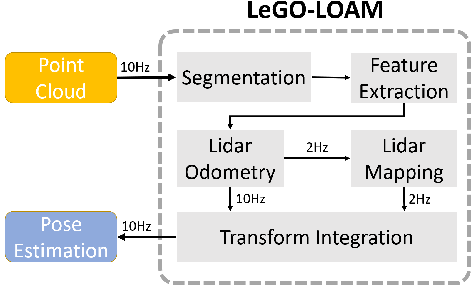
4)作者RobustFieldAutonomyLab,https://github.com/RobustFieldAutonomyLab/LeGO-LOAM/
This repository contains code for a lightweight and ground optimized lidar odometry and mapping (LeGO-LOAM) system for ROS compatible UGVs. The system takes in point cloud from a Velodyne VLP-16 Lidar (placed horizontal) and optional IMU data as inputs. It outputs 6D pose estimation in real-time.
The author use IMU integration to obtain the initial guess between two lidar transformation.
2.2 运行LOAM
roslaunch loam_velodyne loam_velodyne.launch
1)跑数据集
read from velodyne [VLP16 sample pcap] (https://midas3.kitware.com/midas/folder/12979)
roslaunch velodyne_pointcloud VLP16_points.launch pcap:="/home/laboshinl/Downloads/velodyne.pcap"
play sample velodyne data from [VLP16 rosbag] (https://db.tt/t2r39mjZ). “-r 0.5”降低数据播放频率
rosbag play ~/Downloads/velodyne.bag -r 0.5
2)利用VLP16实时采集数据
roslaunch velodyne_pointcloud VLP16_points.launch calib:="/path/to/VLP16.yaml"
在RVIZ里面,在PointCloud2选项卡中添加/velodyne_cloud_registered,设置decay time为1000ms。

2.3 运行Lego-LOAM
roslaunch lego_loam run.launch
Notes: The parameter "/use_sim_time" is set to "true" for simulation, "false" to real robot usage.
1)跑数据集
rosbag play *.bag --clock --topic /velodyne_points /imu/data
--clock 是个巨坑,详情参考,https://www.cnblogs.com/gdut-gordon/p/10643426.html
2)用VLP16和IMU采集实时数据
roslaunch velodyne_pointcloud VLP16_points.launch calib:="/path/to/VLP16.yaml"

rosrun lpms_imu lpms_imu_node _sensor_model:="LPMSB2-9BA395" _port:="00:04:3E:9B:A3:95" /imu:=/imu/data
Notes:
在lego_loam中,作者并没有进行lidar和imu的联合标定!作者仅仅把lidar和imu的坐标系三个轴方向对齐,坐标系原点存在偏移。
如果想联合标定IMU和lidar,可参考以下博文。
https://www.cnblogs.com/gdut-gordon/p/10146050.html
三、LeGO-Loam的融合里程计
可以通过 /tf 来查看融合后的里程计。
3.1 如何查看ROS中的 /tf 信息
1) rviz中添加 /TF 选项卡可视化;
2) 利用 /tf 的命令行功能查看;
3.2 融合里程计的 /tf 表示
节点/featureAssociation 发布了雷达里程计,frame id为 /laser_odom,10HZ;
节点/mapOptmization 发布了地图优化的里程计,frame id为 /aft_mapped,2HZ;
节点/transformFusion 订阅了来自上述两个节点的里程计topic,融合计算,发布最终的里程计,frame id为 /camera, 10HZ;
以上3个 /tf 信息流,其 parent frame id 都是 /camera_init。
注意:camera指的是lidar!IMU 的 /tf 数据流并没有发布出来!

想法、问题记录:
2. As stated in https://github.com/daobilige-su/loam_velodyne using loam for one of the test data gates_oscillating_motion.bag does not get the clear result as in the demo video of the original author. http://www.frc.ri.cmu.edu/%7Ejizhang03/Videos/gates_oscillating_motion.mp4
In my thought it might be an issue of IMU data processing in the code, as gates_oscillating_motion.bag containing IMU data, and in my experience including IMU data does not improve loam.
3. loam-velodyne的改进方案
Change point type to PointXYZINormal, and store original coordinate and intensity data, which are useful for applications like land markers recognition or ground segmentation, to normal and curvature, respectively.
https://github.com/tcts-mvcp/loam_velodyne
fix a bug on laserOdometry.cpp to get rid of the matrix NaN error during L-M optimization step
https://github.com/daobilige-su/loam_velodyne
7. #About ring#However, it failed. I debugged the node and found that KITTI dataset just provide 4 values (x y z intensity) without rings. When I read the code, I noticed that rings value can be determined by elevation of every point, and I am trying to use the same scheme
9. cloudcompare
10.Jacobian matrix
https://github.com/laboshinl/loam_velodyne/issues/3#issuecomment-354786065https://github.com/laboshinl/loam_velodyne/issues/3#issuecomment-374575581
11.How to visualize the fully registered map in RViz
How to save the fully registered map in .pcd**
https://github.com/laboshinl/loam_velodyne/issues/3#issuecomment-385203738
https://github.com/laboshinl/loam_velodyne/issues/41
使用velodyne16线激光雷达跑loam-velodyne的更多相关文章
- 使用ros_driver运行velodyne16线激光雷达
一.使用ros_driver运行VLP16 推荐网址: http://blog.csdn.net/littlethunder/article/details/51920681 https://www. ...
- lego loam 跑镭神32线激光雷达
师弟反应镭神32线激光雷达(32C)录制的数据包不能跑lego loam,这里就总结一下. 首先lego loam默认的接受的topic name是velodyne_points,点云的frame_i ...
- 激光雷达 LOAM 论文 解析
转自:https://blog.csdn.net/hltt3838/article/details/109261334 固态激光雷达的一段视频:https://v.qq.com/x/page/a078 ...
- Velodyne VLP-16激光雷达数据分析
Velodyne VLP-16激光雷达数据分析 Velodyne VLP-16激光雷达保持了 Velodyne 在 LiDAR 中的突破性重要功能:实时收发数据.360 度全覆盖.3D 距离测量以及校 ...
- Lidar激光雷达市场
Lidar激光雷达市场 近年来,激光雷达技术在飞速发展,从一开始的激光测距技术,逐步发展了激光测速.激光扫描成像.激光多普勒成像等技术,如今在无人驾驶.AGV.机器人等领域已相继出现激光雷达的身影. ...
- TOF摄像机可以替代Flash激光雷达吗?
TOF摄像机可以替代Flash激光雷达吗? 一.基于ToF技术的Flash激光雷达 基本成像原理上ToF Camera与LiDAR相同,都采用飞行时间测距技术(包括利用APD或SPAD的直接测距法,和 ...
- 用于激光雷达的 APD,SPAD 和 SiPM 分析
1. 术语及定义 1.1 激光雷达,Light Detection And Range, LiDAR 发射激光光束,并接收回波以获取目标三维和/或速度信息的系统: 1.2 机械旋转激光雷达,Mech ...
- Metrics:如何让线上应用更加透明?
1. 上期我们结合<SRE Google 运维解密>,对监控系统进行了一次脉络梳理,知道一旦离开了监控系统,我们就没法辨别一个服务是不是在正常提供服务,就如同线上的服务在随风裸奔. 文章分 ...
- Autoware 培训笔记 No. 4——寻迹
1. 前言 好多初创公司公布出来的视频明显都是寻迹的效果,不是说寻迹不好,相反可以证明,寻迹是自动技术开始的第一步. 自动驾驶寻迹:一种能够自动按照给定的路线(通常是采用不同颜色或者其他信号标记来引导 ...
随机推荐
- nc/netcat命令
nc/netcat命令 语法 nc/netcat(选项)(参数) 选项 -g<网关>:设置路由器跃程通信网关,最多设置8个: -G<指向器数目>:设置来源路由指向器,其数值为4 ...
- Shell 函数相关
一.函数的两种定义方式 第一种:函数名(){ ...... } 第二种:function 函数名{ ...... } 调用时直接使用 函数名 调用,将函数当作一个“命令”即可.函数内部直接使用 $1. ...
- Groovy学习笔记-Java 5新特性支持
1.枚举enum enum CoffeeSize{ SHORT, SMALL, MEDIUM, LARGE, MUG } def orderCoffee(size){ print "Coff ...
- 最新工控\建模仿真\组态\监控集成开发平台源码解决方案2019 ---所有VC++源码100%提供!
使用E-Form++可视化企业版本,构建属于自己的专业工控.建模仿真. 监控组态.培训仿真平台! -- 100%源码 (全部采用VC++/MFC编写,支持.NET, Java, Web, Delphi ...
- python笔记1——关于文件的打开与读写
一.文件的打开与关闭1.open,close函数 #-*- coding:utf-8 -*- # 1.w 写模式,它是不能读的,如果用w模式打开一个已经存在的文件,会清空以前的文件内容,重新写 # w ...
- [配置] win下maven配置
下载解压 打开环境变量 新建MAVEN_HOME 路径为maven根文件夹 PATH 末尾添加 %MAVEN_HOME%\bin; 命令行 mvn -v 检查 添加网易maven镜像库 阿里的也可以 ...
- jQuery图片自动添加水印插件
JS脚本(jQuery)为图片加水印效果预览:http://hovertree.com/texiao/jquery/94/ 本功能使用HTML5实现,可为图片加上文字水印,可设置文字,设置颜色,位置等 ...
- python 11
# 一.闭包 # # 判断:函数名.__closure__ # 若返回cell,则是闭包,返回None则不是闭包. # # 闭包:内层函数对外层函数非全局变量的引用就叫闭包. def func1(x) ...
- jmeter链接数据库
1.下载jar包“mysql-connector-java-8.0.12”包放入lib文件中 2.启动jemeter,添加线程组 3.在线程组下添加 JDBC Connection Configura ...
- python开发流程及项目目录规范
# 项目开发流程 1.调研 2.需求分析 ---产品经理 3.任务分配 ---项目经理 4.写项目demo ---项目经理.架构师.程序猿 5.架构分析 ---项目经理.架构师 6.编 ...
