openlayers6结合geoserver实现地图属性查询(附源码下载)
前言
之前写过一篇 openlayers4 版本的地图属性查询文章,但是由于是封装一层 js 代码写的,很多初学者看起来比较有点吃力,所以本篇文章重新写一篇地图属性查询文章,直接基于最新版本 openlayers6 写的,纯粹 html + js + css形式,没有任何封装。
内容概览
1.基于 openlayers6 实现地图属性查询
2.源代码 demo 下载
效果图如下: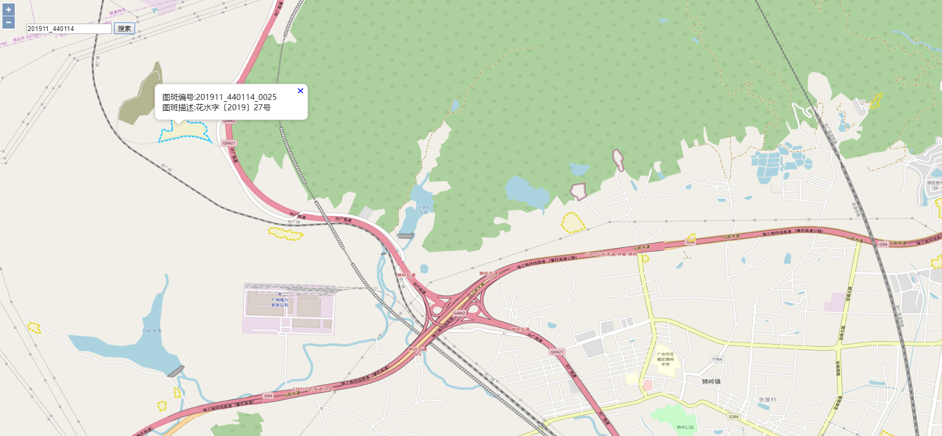
具体实现过程
- html 样式
html, body, #map {

height: 100%;

padding: 0;

margin: 0;

}

.ol-popup {

position: absolute;

background-color: white;

-webkit-filter: drop-shadow(0 1px 4px rgba(0,0,0,0.2));

filter: drop-shadow(0 1px 4px rgba(0,0,0,0.2));

padding: 15px;

border-radius: 10px;

border: 1px solid #cccccc;

bottom: 12px;

left: -50px;

min-width: 280px;

}

.ol-popup:after, .ol-popup:before {

top: 100%;

border: solid transparent;

content: " ";

height: 0;

width: 0;

position: absolute;

pointer-events: none;

}

.ol-popup:after {

border-top-color: white;

border-width: 10px;

left: 48px;

margin-left: -10px;

}

.ol-popup:before {

border-top-color: #cccccc;

border-width: 11px;

left: 48px;

margin-left: -11px;

}

.ol-popup-closer {

text-decoration: none;

position: absolute;

top: 2px;

right: 8px;

}

.ol-popup-closer:after {

content: "✖";

}
- 矢量图层默认样式以及高亮样式
//绘制geojson矢量图层样式

var geoJsonStyle = new ol.style.Style({

stroke: new ol.style.Stroke({

color: '#e6d933',

lineDash: [4],

width: 3

}),

fill: new ol.style.Fill({

color: 'rgba(255, 255, 0, 0.1)'

})

});

//绘制geojson矢量图层高亮样式

var geoJsonHLightStyle = new ol.style.Style({

stroke: new ol.style.Stroke({

color: '#33CCFF',

lineDash: [4],

width: 3

}),

fill: new ol.style.Fill({

color: 'rgba(255, 255, 0, 0.1)'

})

});
- 创建矢量图层以及地图底图
var geojsonLayer = new ol.layer.Vector({

source: new ol.source.Vector(),

style: geoJsonStyle

});

var layers = [

new ol.layer.Tile({

source: new ol.source.OSM()

}),

/*new ol.layer.Tile({

source: new ol.source.TileArcGISRest({

url: 'https://server.arcgisonline.com/arcgis/rest/services/World_Imagery/MapServer'

})

}),*/

geojsonLayer

];
- 创建地图
var map = new ol.Map({

layers: layers,

overlays: [overlay],

target: 'map',

view: new ol.View({

projection: 'EPSG:4326',

center: [104.114129, 37.550339],

zoom: 4

})

});
- 监听地图鼠标移动事件,设置选择矢量图层要素高亮以及弹出气泡窗口效果
//监听地图鼠标移动事件

map.on('pointermove',function(e) {

if (e.dragging) {

return;

}

var feature =map.forEachFeatureAtPixel(e.pixel,

function(feature) {

return feature;

});

//console.log('feature',feature);

if(feature==undefined){//捕捉不到矢量数据,设置矢量图层默认样式

geojsonLayer.getSource().forEachFeature(function(feature) {

feature.setStyle(geoJsonStyle);

});

//隐藏气泡窗口

overlay.setPosition(undefined);

closer.blur();

}else{//捕捉到矢量数据,设置矢量图层高亮样式

feature.setStyle(geoJsonHLightStyle);

//弹出气泡窗口

var coordinate = e.coordinate;

content.innerHTML = '图斑编号:'+feature.values_.map_num+'</br>图斑描述:'+feature.values_.description;

overlay.setPosition(coordinate);

}

})
- 属性查询核心函数
var geoserverUrl = 'http://localhost:8080/geoserver/GIS';

/*属性查询图层

*@method queryByProperty

*@param propertyValue 属性值

*@param propertyName 属性名称

*@param typeName 图层名称

*@return null

*/

function queryByProperty(propertyValue, propertyName, typeName, callback){

var filter =

'<Filter xmlns="http://www.opengis.net/ogc" xmlns:gml="http://www.opengis.net/gml">';

……
完整demo源码见小专栏文章尾部:GIS之家openlayers小专栏
文章尾部提供源代码下载,对本专栏感兴趣的话,可以关注一波
openlayers6结合geoserver实现地图属性查询(附源码下载)的更多相关文章
- cesium 结合 geoserver 实现地图属性查询(附源码下载)
前言 cesium 官网的api文档介绍地址cesium官网api,里面详细的介绍 cesium 各个类的介绍,还有就是在线例子:cesium 官网在线例子,这个也是学习 cesium 的好素材. 内 ...
- leaflet 结合 geoserver 实现地图属性查询(附源码下载)
前言 leaflet 入门开发系列环境知识点了解: leaflet api文档介绍,详细介绍 leaflet 每个类的函数以及属性等等 leaflet 在线例子 leaflet 插件,leaflet ...
- openlayers6结合geoserver实现地图空间查询(附源码下载)
前言 之前写过一篇 openlayers4 版本的地图空间查询文章,但是由于是封装一层 js 代码写的,很多初学者看起来比较有点吃力,所以本篇文章重新写一篇地图空间查询文章,直接基于最新版本 open ...
- cesium结合geoserver实现地图空间查询(附源码下载)
前言 cesium 官网的api文档介绍地址cesium官网api,里面详细的介绍 cesium 各个类的介绍,还有就是在线例子:cesium 官网在线例子,这个也是学习 cesium 的好素材. 内 ...
- openlayers6结合geoserver实现地图矢量瓦片(附源码下载)
内容概览 1.基于openlayers6结合geoserver实现地图矢量瓦片2.源代码demo下载 效果图如下: 实现思路:利用Geoserver发布矢量切片服务,然后openlayers调用矢量瓦 ...
- leaflet 结合 geoserver 实现地图空间查询(附源码下载)
前言 leaflet 入门开发系列环境知识点了解: leaflet api文档介绍,详细介绍 leaflet 每个类的函数以及属性等等 leaflet 在线例子 leaflet 插件,leaflet ...
- openlayers6实现webgl点图层渲染效果(附源码下载)
前言:openlayers6推出来的有一段时间,推出来的新特性见:https://github.com/openlayers/openlayers/releases/该版本的主要功能是能够组合具有不同 ...
- arcgis api 3.x for js 热力图优化篇-不依赖地图服务(附源码下载)
前言 关于本篇功能实现用到的 api 涉及类看不懂的,请参照 esri 官网的 arcgis api 3.x for js:esri 官网 api,里面详细的介绍 arcgis api 3.x 各个类 ...
- arcgis api 3.x for js 入门开发系列十一地图统计图(附源码下载)
前言 关于本篇功能实现用到的 api 涉及类看不懂的,请参照 esri 官网的 arcgis api 3.x for js:esri 官网 api,里面详细的介绍 arcgis api 3.x 各个类 ...
随机推荐
- DNS服务反向解析及过程中一些小问题解决
在此需要了解一下,反向解析的作用是根据IP地址查找到对应的主机名(域名),在区域文件(named.rfc1912.zones)中默认已存在一些注释内容与区域信息,可不需要删除上面实验及默认区域信息,直 ...
- 深入理解计算机系统 第二章 信息的表示和处理 Part2 第二遍
<深入理解计算机系统> 第三版 第二遍读这本书,每周花两到三小时时间,能读多少读多少(这次看了 29 ~ 34 页) 第一遍对应笔记链接 https://www.cnblogs.com/s ...
- nuxt遇到的问题(一)window 或 document is not defined
因为用了VUE做的官网,既然是官网了避免不了SEO的问题了(该死当初就不应该选择用vue) 很自然就是选择了使用nuxt.js来做ssr预渲染了. 因为网站不是响应式的,PC / 移动端要进行对应跳转 ...
- 一个ip, 两个域名, 两个ssl, 访问多个不同的项目
在前面一篇中说过, 入了好几个坑. 后来使用了nginx+tomcat配置的方式. 终于成功了. 因为头一次使用nginx, 不知道具体怎么操作, 于是我在操作的时候, 按照以下几个步骤执行的: 导航 ...
- AutoCad 二次开发 文字镜像
AutoCad 二次开发 文字镜像 参考:https://adndevblog.typepad.com/autocad/2013/10/mirroring-a-dbtext-entity.html 在 ...
- 装饰者模式学习:模拟咖啡馆的点单系统来剖析装饰者模式的使用 + 装饰者模式在java I/O 中的应用
通过模拟咖啡馆的点单系统来剖析装饰者模式的使用 参考:https://blog.csdn.net/gududedabai/article/details/81989196 一).传统的点单系统构建,每 ...
- 使用图数据库 Nebula Graph 数据导入快速体验知识图谱 OwnThink
前言 本文由 Nebula Graph 实习生@王杰贡献. 最近 @Yener 开源了史上最大规模的中文知识图谱--OwnThink(链接:https://github.com/ownthink/Kn ...
- 详解在Linux系统中安装JDK
本文以在CentOS 7.6中安装JDK8为例进行安装,其他系统和版本都是大同小异的. 下载 进入Oracle官方网站的下载页面. 首先,接受许可协议,如下图: 然后,根据Linux系统的位数选择要下 ...
- 菜鸟系列Fabric源码学习—orderer服务启动
Fabric 1.4 orderer 服务启动流程 1.提要 orderer提供broadcast和deliver两个服务接口.orderer节点与各个peer节点通过grpc连接,orderer将所 ...
- API规范约定
为了高效开发,节约编写文档的成本,API服务使用Swagger来描述 一.API设计原则 控制API的粒度和数量 命名要遵循简单.可读.统一原则: 优先设计API,然后编码 二.URL设计[针对后端开 ...