天津政府应急系统之GIS一张图(arcgis api for flex)解说(三)显示地图坐标系模块
config.xml文件的配置例如以下:
|
1
2
|
<widget"3" bottom="3"config="widgets/Coordinate/CoordinateWidget.xml" url="widgets/Coordinate/CoordinateWidget.swf" /> |
源码文件夹例如以下:
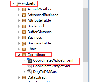
地图坐标系模块的源码原理解析,具体的代码在下载的开源flexviewer自带的:
(1)CoordinateWidget.xml
1 <?

xml version="1.0" ?>

2 <configuration label="Coordinates (default)">

3     <!-- geo, dms, mercator 主要是坐标输出单位。默认的是经纬度 -->

4     <outputunit>geo</outputunit>

5 </configuration>
(2)CoordinateWidget.mxml

  1 <?xml version="1.0" encoding="utf-8"?>

 19 <viewer:BaseWidget xmlns:fx="http://ns.adobe.com/mxml/2009"

 20                    xmlns:s="library://ns.adobe.com/flex/spark"

 21                    xmlns:mx="library://ns.adobe.com/flex/mx"

 22                    xmlns:viewer="com.esri.viewer.*"

 23                    layout="horizontal"

 24                    widgetConfigLoaded="basewidget_widgetConfigLoadedHandler(event)">

 25     <fx:Script>

 26         <![CDATA[

 27             import com.esri.ags.events.MapEvent;

 28             import com.esri.ags.geometry.MapPoint;

 29             import com.esri.ags.utils.WebMercatorUtil;

 30

 31             import mx.formatters.NumberBaseRoundType;

 32             import mx.utils.StringUtil;

 33

 34             private var m_template:String;

 35             private var m_func:Function = substitute;

 36

 37             protected function basewidget_widgetConfigLoadedHandler(event:Event):void

 38             {

 39                 if (configXML)

 40                 {

                        //以下是读取CoordinateWidget.xml配置文件的资源。要是配置了的话

 41                     const decimalSeparator:String = configXML.numberformatter.@decimalseparator;

 42                     numberFormatter.decimalSeparatorTo = decimalSeparator ? decimalSeparator : ".";

 43                     const thousandsSeparator:String = configXML.numberformatter.@thousandsseparator;

 44                     numberFormatter.thousandsSeparatorTo = thousandsSeparator ?

thousandsSeparator : ",";

 45                     numberFormatter.useThousandsSeparator = configXML.numberformatter.@usethousandsseparator == "true";

 46                     numberFormatter.precision = parseFloat(configXML.numberformatter.@precision || "-1");

 47                     const rounding:String = configXML.numberformatter.@rounding;

 48                     numberFormatter.rounding = rounding ? rounding : NumberBaseRoundType.NONE;

 49                     //获取设置坐标显示的字体和颜色样式等

 50                     const color:String = configXML.labelstyle.@color[0] || configXML.label.@color[0];

 51                     coords.setStyle("color", toNumber(color ? color : "0x000000"));

 52                     const fontFamily:String = configXML.labelstyle.@fontfamily[0] || configXML.label.@fontfamily[0];

 53                     coords.setStyle("fontFamily", fontFamily ? fontFamily : "Verdana");

 54                     const fontSize:String = configXML.labelstyle.@fontsize[0] || configXML.label.@fontsize[0];

 55                     coords.setStyle("fontSize", parseInt(fontSize ?

fontSize : "9"));

 56                     const fontWeight:String = configXML.labelstyle.@fontweight[0] || configXML.label.@fontweight[0];

 57                     coords.setStyle("fontWeight", fontWeight ?

fontWeight : "bold");

 58

 59                     // If no template specified, show them with a space in between (except for special case below)

 60                     m_template = configXML.labels.template[0] || configXML.label.@template[0] || "{0} {1}";

 61

 62                     if (map.loaded)

 63                     {

 64                         map_loadHandler(null);

 65                     }

 66                     else

 67                     {

 68                         map.addEventListener(MapEvent.LOAD, map_loadHandler);//载入地图

 69                     }

 70                 }

 71

 72                 function map_loadHandler(event:MapEvent):void

 73                 {

 74                     map.removeEventListener(MapEvent.LOAD, map_loadHandler);

 75                     const wkid:int = map.spatialReference.wkid; //获取地图的空间坐标參考系

 76                     m_func = substitute;

 77                     const outputUnit:String = configXML.outputunit;//获取地图的坐标显示单位,从配置文件获取

 78                     if (outputUnit === "mercator")//推断地图的坐标体系。墨卡托情况下运行

 79                     {

 80                         if (wkid === 4326 || wkid === 4269 || wkid === 4267)

 81                         {

 82                             m_func = geographicToMercator;//调用地理坐标系转换墨卡托坐标系

 83                         }

 84                     }

 85                     else if (outputUnit === "geo")//地理坐标系情况下运行

 86                     {

 87                         if (wkid === 102100 || wkid === 102113 || wkid === 3857)

 88                         {

 89                             m_func = mercatorToGeographic;//调用墨卡托坐标系转换地理坐标系

 90                             // special default for geographic outputs

 91                             m_template = configXML.labels.template[0] || configXML.label.@template[0] || getDefaultString("latitudeLabel") + ":{1}   " + getDefaultString("longitudeLabel") + ":{0}";//设置坐标显示的文字,比方经度,纬度

 92                             numberFormatter.precision = parseFloat(configXML.numberformatter.@precision || "6");//设置坐标显示的位数

 93                         }

 94                         else if (wkid === 4326 || wkid === 4269 || wkid === 4267)

 95                         {

 96                             // special default for geographic outputs

 97                             m_template = configXML.labels.template[0] || configXML.label.@template[0] || getDefaultString("latitudeLabel") + ":{1}   " + getDefaultString("longitudeLabel") + ":{0}";

 98                             numberFormatter.precision = parseFloat(configXML.numberformatter.@precision || "6");

 99                         }

100                     }

101                     else if (outputUnit === "dms")//经纬度显示单位为度分秒形式情况下运行

102                     {

103                         if (wkid === 102100 || wkid === 102113 || wkid === 3857)

104                         {

105                             m_func = mercatorToDMS;

106                         }

107                         else if (wkid === 4326 || wkid === 4269 || wkid === 4267)

108                         {

109                             m_func = geographicToDMS;

110                         }

111                     }

112                     map.addEventListener(MouseEvent.MOUSE_MOVE, map_mouseMoveHandler);//监听地图鼠标移动事件,用来获取地图经纬度的

113                 }

114             }

115

116             private function toNumber(value:String):int//转换单位计算

117             {

118                 if (value.substr(0, 2) == "0x")

119                 {

120                     return parseInt(value, 16);

121                 }

122                 return parseInt(value, 10);

123             }

124

125             private function mercatorToGeographic(web:MapPoint):String//墨卡托转换地理坐标系的函数

126             {

127                 const geo:MapPoint = WebMercatorUtil.webMercatorToGeographic(web) as MapPoint;//arcgis api封装好的转换函数

128                 return StringUtil.substitute(m_template,

129                                              numberFormatter.format(geo.x),

130                                              numberFormatter.format(geo.y));

131             }

132

133             private function mercatorToDMS(web:MapPoint):String//墨卡托转换经纬度度分秒形式的函数

134             {

135                 const geo:MapPoint = WebMercatorUtil.webMercatorToGeographic(web) as MapPoint;

136                 return StringUtil.substitute(m_template, DegToDMS.format(geo.x, DegToDMS.LON), DegToDMS.format(geo.y, DegToDMS.LAT));

137             }

138

139             private function geographicToMercator(geo:MapPoint):String//地理坐标系转换墨卡托的函数

140             {

141                 const web:MapPoint = WebMercatorUtil.geographicToWebMercator(geo) as MapPoint;

142                 return StringUtil.substitute(m_template,

143                                              numberFormatter.format(web.x),

144                                              numberFormatter.format(web.y));

145             }

146

147             private function substitute(mapPoint:MapPoint):String

148             {

149                 return StringUtil.substitute(m_template,

150                                              numberFormatter.format(mapPoint.x),

151                                              numberFormatter.format(mapPoint.y));

152             }

153

154             private function geographicToDMS(mapPoint:MapPoint):String

155             {

156                 const x:String = DegToDMS.format(mapPoint.x, DegToDMS.LON);

157                 const y:String = DegToDMS.format(mapPoint.y, DegToDMS.LAT);

158                 return StringUtil.substitute(m_template, x, y);

159             }

160

161             private function map_mouseMoveHandler(event:MouseEvent):void

162             {

163                 const mapPoint:MapPoint = map.toMapFromStage(event.stageX, event.stageY);//获取鼠标移动的地图经纬度

164                 coords.text = m_func(mapPoint);

165             }

166         ]]>

167     </fx:Script>

168

169     <fx:Declarations>

170         <mx:NumberFormatter id="numberFormatter"/>

171     </fx:Declarations>

172     <viewer:filters>

173         <mx:GlowFilter alpha="1"

174                        blurX="3"

175                        blurY="3"

176                        color="0xFFFFFF"

177                        strength="7"/>

178     </viewer:filters>

179     <s:Label id="coords" color="0x000000"/>//显示经纬度的位置。显示label

180 </viewer:BaseWidget>
(3)DegToDMS.as
 1 package widgets.Coordinate

 2 {

 3

 4 /**

 5  * Utility class to pretty print decimal degree numbers.

 6  * @private

 7  */

 8 public final class DegToDMS

 9 {

10     // Constants to define the format.

11     public static const LAT:String = "lat";

12

13     public static const LON:String = "lon";

14

15     /**

16      * Utility function to format a decimal degree number into a pretty string with degrees, minutes and seconds.

17      * @param decDeg the decimal degree number.

18      * @param decDir "lat" for a latitude number, "lon" for a longitude value.

19      * @return A pretty print string with degrees, minutes and seconds.

20      */

21     public static function format(decDeg:Number, decDir:String):String//这个函数主要是用来把经纬度转换度分秒的形式来展示经纬度,比方113度23分23秒等等

22     {

23         var d:Number = Math.abs(decDeg);

24         var deg:Number = Math.floor(d);

25         d = d - deg;

26         var min:Number = Math.floor(d * 60);

27         var av:Number = d - min / 60;

28         var sec:Number = Math.floor(av * 60 * 60);

29         if (sec == 60)

30         {

31             min++;

32             sec = 0;

33         }

34         if (min == 60)

35         {

36             deg++;

37             min = 0;

38         }

39         var smin:String = min < 10 ? "0" + min + "' " : min + "' ";

40         var ssec:String = sec < 10 ?

"0" + sec + "\" " : sec + "\" ";

41         var sdir:String = (decDir == LAT) ? (decDeg < 0 ? "S" : "N") : (decDeg < 0 ?

"W" : "E");

42         return deg + "\xB0 " + smin + ssec + sdir;

43     }

44 }

45

46 }
备注:
GIS作品:百度搜索:GIS之家(https://shop116521643.taobao.com/shop/view_shop.htm);
QQ兴趣部落GIS技术交流:gis之家(http://buluo.qq.com/p/barindex.html?bid=327395);
GIS毕业设计&项目承接群:238339408;
GIS技术交流群:432512093
天津政府应急系统之GIS一张图(arcgis api for flex)解说(三)显示地图坐标系模块的更多相关文章
- 天津政府应急系统之GIS一张图(arcgis api for flex)讲解(一)GIS一张图的系统开发环境以及flexviewer框架
系统的GIS功能实现是基于arcgis api for flex,首先附上系统的主界面图,接下来的是对主界面的模块功能详细讲解: 一.GIS环境软件安装 (1)arcgis desktop的安装,要是 ...
- 天津政府应急系统之GIS一张图(arcgis api for flex)讲解(十)态势标绘模块
config.xml文件的配置如下: <widget label="态势标绘" icon="assets/images/impact_area_over.png&q ...
- 天津政府应急系统之GIS一张图(arcgis api for flex)讲解(三)显示地图坐标系模块
config.xml文件的配置如下: <widget left="3" bottom="3" config="widgets/Coordinat ...
- 天津政府应急系统之GIS一张图(arcgis api for flex)讲解(八)资源搜索模块
config.xml文件的配置如下: <widget label="资源搜索" icon="assets/images/public_impact_over.png ...
- 天津政府应急系统之GIS一张图(arcgis api for flex)讲解(二)鹰眼模块
讲解GIS功能模块实现之前,先大概说一下flexviewer的核心配置文件config.xml,系统额GIS功能widget菜单布局.系统的样式.地图资源等等都是在这里配置的,这里对flexviewe ...
- 天津政府应急系统之GIS一张图(arcgis api for flex)解说(二)鹰眼模块
解说GIS功能模块实现之前,先大概说一下flexviewer的核心配置文件config.xml,系统额GIS功能widget菜单布局.系统的样式.地图资源等等都是在这里配置的,这里对flexviewe ...
- 天津政府应急系统之GIS一张图(arcgis api for flex)讲解(十三)台风模块
config.xml文件的配置如下: <widget label="台风" icon="assets/images/typhoon.png" config ...
- 天津政府应急系统之GIS一张图(arcgis api for flex)讲解(十一)路径导航模块
config.xml文件的配置如下: <widget label="路径导航" icon="assets/images/lujingdaohang.png" ...
- 天津政府应急系统之GIS一张图(arcgis api for flex)讲解(六)地图搜索模块
config.xml文件的配置如下: <widget label="地图搜索" icon="assets/images/emergency_resource_ove ...
随机推荐
- mysql +keeplive+drbd高可用架构
1MySQL+DRBD+keepalived高可用架构 DRBD(DistributedReplicatedBlockDevice)是一个基于块设备级别在远程服务器直接同步和镜像数据的开源软件,类似于 ...
- 28.Linux-IIC驱动(详解)
上一节 我们学习了: IIC接口下的24C02 驱动分析: http://www.cnblogs.com/lifexy/p/7793686.html 接下来本节, 学习Linux下如何利用linux下 ...
- python3 xpath数据获取案例
import requestsfrom retrying import retryfrom lxml import etreeimport json class DaCheng(object): de ...
- Nginx实现负载均衡&Nginx缓存功能
一.Nginx是什么 Nginx (engine x) 是一个高性能的HTTP和反向代理服务器,也是一个IMAP/POP3/SMTP服务器.Nginx是由伊戈尔·赛索耶夫为俄罗斯访问量第二的Rambl ...
- 你有什么理由还不选择阿里云服务器呢--从阿里云发布自研商用关系型数据库POLARDB想到的
最近几天,阿里云发布自研商用关系型数据库POLARDB的消息可谓是重磅炸弹啊.借用官方宣传的话就是:6倍性能于MySQL并100%兼容/100TB存储容量/2分钟创建只读副本/3分钟创建容灾实例,第三 ...
- 多少牛逼的程序员毁在low逼的英文发音上(JAVA)
最最常用的关键词及音标 数据类型:boolean.byte.short.int.long.double.char.float.double. 包引入和包声明:import.package. 用于类和接 ...
- PEP8
1.规则要求 https://www.python.org/dev/peps/pep-0008 2.工具 https://github.com/jcrocholl/pep8 3.基本使用方法 测试自己 ...
- SpringBoot之文件读取
SpringBoot 寻找启动配置文件规则如下: 当前目录下的 config 目录 当前目录 classpath 下的 config 目录 classpath 下的 root 目录(根路径) 上面的优 ...
- 多个Fragment的分开管理方案
当项目里有多个Fragment的时候 我们希望让Fragment有个分类 并且展示的时候不会混淆在一起 例如:项目中导航栏有三个按钮 每个按钮对应一种分类的布局,每个分类的布局中有多个Fragm ...
- ArrayList迭代过程删除问题
一:首先看下几个ArrayList循环过程删除元素的方法(一下内容均基于jdk7): package list; import java.util.ArrayList; import java.uti ...