ArcMap 发布地图服务,提示发布工具没有启动
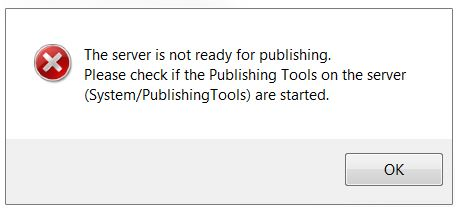
Error: The server is not ready for publishing. Please check if the Publishing Tools on the server are started。
Cause
There are several potential causes for this error:
- The Publishing Tools service on ArcGIS for Server is not started or is in a stopped state.
- The connection between the local machine and ArcGIS for Server is unstable or intermittent. This causes ArcGIS for Server to be unable to establish communication with other machines and returns the error.
- Processing and memory limitations of the server may return the error. The server crashes or becomes unresponsive when overloaded with requests or is unable to process the large amount of data.
Solution or Workaround
The following workarounds can be applied depending on the cause:
Publishing Tools service is not started or in a stopped state
Ensure the Publishing tool service is started. For more information, refer to ArcGIS Help: Starting and stopping services.
Unstable or intermittent connection
If the connection is unstable or intermittent, save a service definition (.sd) file using ArcMap and publish the .sd file directly from ArcGIS Server Manager.
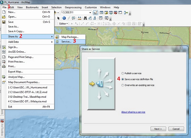
- In ArcMap, navigate to File > Share As > Service. When prompted, select Save a service definition file and click Next.
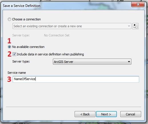
- In the Save a Service Definition window, select No available connection, check Include data in service definition when publishing, and provide a name for the service.
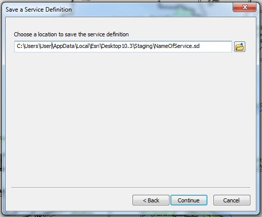
- When prompted, select a location to save the service definition and click Continue
- In the Service Editor dialog box, make the necessary changes to the properties where needed, and click Analyze.
Note:

When publishing from ArcGIS for Desktop, select Feature Access > Service Editor > Capabilities > Feature Access. This creates a URL to access the feature service over the web.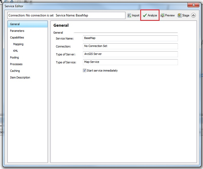
- To complete the process, on the top right of the Service Editor window, click Stage.
Note:

The Analyze function checks if there are any potential performance issues before publishing a GIS resource as a service. The Stage function compiles a service definition file with all the relevant information needed to publish a GIS service, including data that must be copied to the server because it does not appear in the server's data store. - Publish the service definition file in ArcGIS Server Manager. To do so, refer to ArcGIS Help: Publish a service definition in ArcGIS Server Manager.
Restart ArcMap and republish the MXD.
ArcMap 发布地图服务,提示发布工具没有启动的更多相关文章
- JavaWeb和WebGIS学习笔记(六)——使用ArcGIS for Server发布地图服务
系列链接: Java web与web gis学习笔记(一)--Tomcat环境搭建 Java web与web gis学习笔记(二)--百度地图API调用 JavaWeb和WebGIS学习笔记(三)-- ...
- 手把手教你怎么用ArcgisOnline发布地图服务
Arcgis推出了Arcgis Online,但是大家都不知道这是个什么东西,怎么用这个东西,今天这篇文章手把手的教你如何使用Arcgisonline发布地图服务. 一.ArcgisOnline简介 ...
- ArcGIS发布地图服务
一般做完矢量图绘制工作后,生成的.mxd文件只能在ArcMap中查看,为了方便用户进行浏览,我们需要发布地图服务. 目前为止最常用的就是在ArcGIS中发布地图服务. 今天也算是在做“发布地图服务”的 ...
- ArcGIS 10.2之地图服务的发布、使用
2.发布地图服务 2.1 地图服务器的建立 打开ArcCatalog,在左侧的GIS Servers下,双击Add ArcGIS Server, 弹出添加界面,选择,Administer GIS服务项 ...
- 利用 PortableBasemapServer 发布地图服务
前段时间需要给自己的C/S系统加一个地图,但是没有数据,于是就想到了使用网上的切片地图,但是C/S系统又不能联网,于是就想本地发布切片服务来使用. 本来想用ArcGIS Server来发布从网上下载的 ...
- 动态创建地图文档MXD并发布地图服务
原文:动态创建地图文档MXD并发布地图服务 1.动态创建MXD private bool CreateMxd(string MxdPath, string MxdName) { IMapDocumen ...
- geoserver 通过代码实现发布地图服务
GeoServer:代码实现批量发布地图服务 利用GeoServer发布WCS服务,那么如果我有很多数据需要进行发布,这样利用GeoServer提供的UI界面进行操作显然很不显示.那能不能利用GeoS ...
- 基于GeoServer切片地图服务的发布
接着上一篇文章,如何将JPG格式的图片转化为带地理坐标的TIFF格式里提及的最近的一个项目,数据源是一张高分辨率的2.5维图片,现在已经成功转化成了带有地理坐标的TIFF格式.下面将介绍借助GeoSe ...
- GeoServer自动发布地图服务
1 NetCDF气象文件自动发布案例 GeoServer是一个地理服务器,提供了管理页面进行服务发布,样式,切片,图层预览等一系列操作,但是手动进行页面配置有时并不满足业务需求,所以GeoServer ...
- arcgis server10.2发布地图服务报错
发布地图服务时,读取了本机电脑中的切片方案.发布服务,报打包成功,但发布失败错误. 解决办法:给arcgis账户,赋予读写权限即可.重复发布服务,成功发布.
随机推荐
- asp.net core 3.x 身份验证-2启动阶段的配置
注册服务.配置选项.添加身份验证方案 在Startup.ConfigureServices执行services.AddAuthentication() 注册如下服务(便于理解省略了部分辅助服务): s ...
- Android Webview实现有道电子词典
毕业设计android电子词典,先实现的一个小小的demo. 所谓的毕业设计就是用最短的时间学习一门语言,做出一个小的project. activity_main.xml <LinearLayo ...
- 移动端H5优化
H5前端优化收藏的网址: https://zhuanlan.zhihu.com/p/25176904 http://tgideas.qq.com/webplat/info/news_version3/ ...
- 【CMake】CMake GUI构建VS等项目
一.CMake官网(https://cmake.org/)上的介绍: CMake is an open-source, cross-platform family of tools designed ...
- 杭电-------2048不容易系列之(4)考新郎(C语言)
/* 思路:有n位新郎,但是又m位新郎会找错,那么有n-m位新郎会找对,而找对的n-m位新郎的找发就是在 n位新郎中随机找n-m位有多少种排列组合公式有n!/(m!*(n-m!)),而另外找错的新郎则 ...
- Leetcode面试题17.20_连续中值
题目地址 实现一个数列的动态添加和查询中位数. 复杂点的话应该可以写个平衡树什么的,然后查询第k大,还可以删除数字. 简单点的话显然可以维护两个堆,一个大顶堆一个小顶堆,而且大顶堆最多比小顶堆多一个, ...
- Day17-18前端学习之路——Javascript事件
用户在某个元素上点击鼠标或悬停光标. 用户在键盘中按下某个按键. 用户调整浏览器的大小或者关闭浏览器窗口. 一个网页停止加载. 提交表单. 播放.暂停.关闭视频. 发生错误. 更多事件:https:/ ...
- webapi使用jwt做权限验证
考虑到很多公司目前并没有切换到.netcore,所有本文尝试使用.netframework下的webapi 首先使用Nuget 安装 jwt包 安装完成后,创建 jwt的帮助类 public clas ...
- vscode安装使用
1.新建文件:cmd+n2.设置默认浏览器: https://blog.csdn.net/zSY_snake/article/details/83449571 3.view in browser不支持 ...
- Linux运维--实践-Rally
1.rally简介 OpenStack Rally 是一个自动化测试工具,社区希望通过 Rally 来解答 "How does OpenStack work at scale?(如何规模化运 ...